virtual earth and 3d tours of your locations
with the latest release of the maps.live.com site and virtual earth v6, there are some cool end-user features that you can take advantage of as well. one of them is the ability to create a virtual tour of your collections (a collection is a group of waypoints you've saved in your profile.
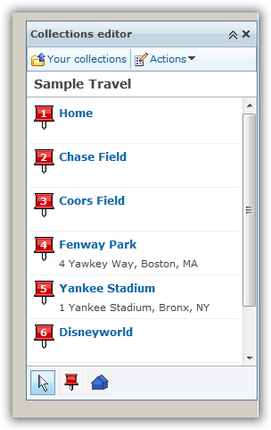
perhaps you have a collection of your favorite vacation spots, or your locations of your organization's offices, or your an individual speaker and want a virtual tour of your stops for some odd reason. well now you can and there are a few ways to do it. first, head on over to http://maps.live.com and sign in (not required, but is required to save a collection). to create a collection, simply search for locations and then you'll have the option to "add to collection" which you would do. i created a collection of places starting at my house, then to a few baseball stadiums, then to disney and vegas...c'mon, sounds like a great trip! here's what it looks like:
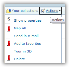
after i have a collection, i have a few options. from the actions menu (of the collections pane) i can immediately do a tour in 3d:
this uses the virtual earth 3d control, which is available as a download (free) for internet explorer and firefox. when i choose that option, the 3d tour starts and my first point in my collection. on the left side i now see a tour pane:
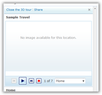
had i edited the properties of my waypoints with other metadata like a photo, notes, etc. they would have showed up in this area. you may also notice the play and record buttons on the bottom of that area. here's were some of the other sharing comes into play (note: i can click the share button to send someone an email link to the tour as well). let's say i want a video of this location tour for youtube, soapbox or whatever...simple, use the new record feature to create a windows media video file of the 3d tour. when you hit record, it starts the tour over. now the recording takes considerably longer than the normal playback, but that is because it is recording the various frames and encoding at the same time to create the resulting file.
when completed, you'll see that you have a completed file. you can now post this wherever you'd like. for example, here's my tour using silverlight streaming (note: i've realized you just have to let your machine record...some of mine seemed to have got screwed up by me doing other activities -- and the titles are automatically added based on the waypoint titles):
pretty cool new feature i think provided by virtual earth and the live platform. go forth and create.
Please enjoy some of these other recent posts...